


Where to Find the Sydney Airport Terminal 1 Map
- Where to find the official Sydney Airport T1 map
- What the Terminal 1 maps show
- How to find your boarding gate on the T1 departures map
- Finding facilities and ground transport at T1
- Using an indoor map or finding an accessible route
- Does the T1 map include Sydney Airport domestic terminals?
- The best map to use for your journey
Where to find the official Sydney Airport T1 map
Open the Sydney Airport terminal maps page, then go to the “T1 International” section. The maps are available as downloadable PDFs, so you can save the relevant file to your phone or print it before travelling.
The airport publishes these three practical maps for international passengers:
- T1 International Departures map — check-in counters, passport control, screening, boarding gates and airside facilities.
- T1 International Arrivals – Before passport control — arrival piers, passport control, baggage reclaim and screening areas.
- T1 International Arrivals – After passport control — arrivals halls, meeting points, parking and ground transport access.
Use the official maps page as your starting point whenever you need a fresh copy. A saved PDF is useful for orientation, but signs and flight information displays at the terminal take precedence if an operational arrangement changes.
What the Terminal 1 maps show
Departures: check-in, security and boarding gates
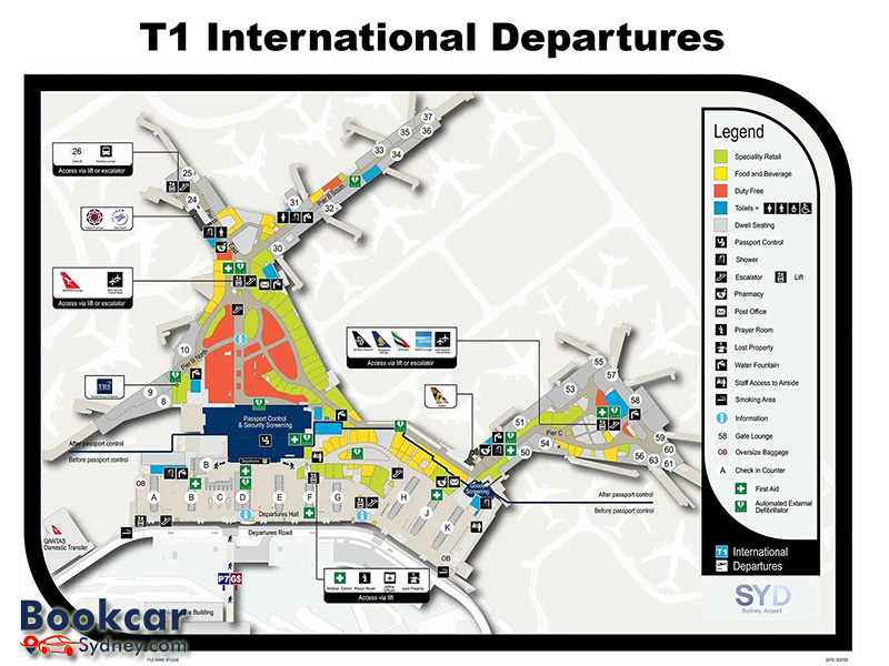
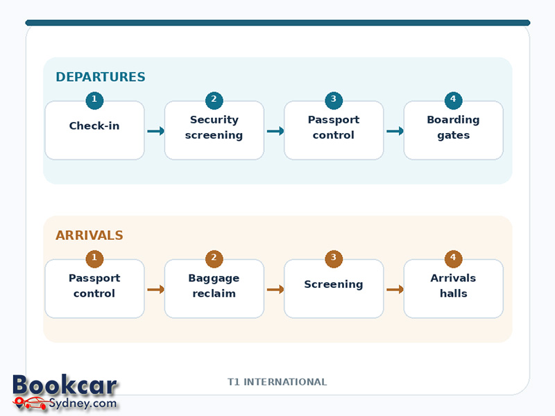
The departures map shows the check-in hall along Departures Road, with counter zones marked from A to K. After check-in, the main passenger route leads towards security screening and passport control, then on to the gate areas. The map also identifies the main international boarding piers, including Pier B and Pier C.
Individual gate locations are marked on the map, including gates in the 8–10, 24–37 and 50–63 groups. Some gates have particular access arrangements: for example, the map identifies Gate 26 as a bussing lounge reached by lift or escalator. Use your confirmed gate number to locate the appropriate pier and follow signs from the central departures area.
Arrivals: passport control, baggage and exits
The arrivals map for the area before passport control helps inbound passengers locate the arrival piers, passport control, baggage carousels and secondary screening. It is most useful while you are still moving through the controlled arrivals areas.
The separate map for the area after passport control shows how the terminal connects to Arrivals Hall A and Arrivals Hall B and the surrounding transport facilities. It marks locations such as meeting points, the train station, taxi and rideshare areas, bus stops and public pick-up zones. Choose this map if you are meeting someone or organising onward transport.
How to find your boarding gate on the T1 departures map
A terminal map shows where each gate is, but it does not confirm which gate your particular flight will use. Your airline’s boarding pass and the airport’s flight information display screens are the appropriate places to check the gate assigned to your departure.
- Confirm that your flight departs from T1 International, rather than T2 or T3 Domestic.
- Look for your airline and flight number on the airport’s departures screens to confirm the current gate.
- Find that gate number on the T1 departures PDF, then identify its pier and nearby lifts, escalators or walking route.
- Follow the directional signs inside the terminal and check the display screens again if your gate is changed.
Allow time for check-in, security and passport control before heading for a distant pier. The physical map is a wayfinding aid, not a substitute for the flight information shown at the airport.
Finding facilities and ground transport at T1
Each T1 map has a legend that explains the services and icons marked on the plan. Depending on which part of the terminal it covers, you can use the map to find:
- Toilets, accessible toilets, lifts and escalators.
- Food outlets, shops and duty-free areas in the departure concourse.
- Information points, first-aid facilities, drinking fountains and other passenger services.
- Baggage reclaim areas and passenger exits in the international arrivals section.
- Transport connections such as the airport train station, taxis, rideshare pick-up, buses and terminal-transfer services.
A useful approach is to select the correct arrivals or departures PDF first, then look for the relevant icon in the legend. For a specific business or lounge, confirm its present location using the airport’s facilities listings or terminal signs.
Using an indoor map or finding an accessible route
If you prefer to navigate on your phone, Sydney Airport also identifies Google Maps Indoor Live View and other wayfinding options for finding terminal facilities. The airport provides wayfinding kiosks inside the terminals as well. Indoor navigation can help when you need to locate a nearby bathroom, baggage area or shop while moving through T1.
For mobility or sensory needs, the official maps page includes separate T1 departures and arrivals sensory maps. Sydney Airport also explains the accessible services available at T1, including lifts and accessible facilities. When using Google Maps, the airport recommends selecting its wheelchair-accessible route preference where appropriate.
A digital map can help you plan a route, but terminal signs, staff directions and any airline-specific assistance arrangements remain important on the day.
Does the T1 map include Sydney Airport domestic terminals?
No. T1 International is in a different terminal precinct from the T2 and T3 Domestic terminals. The official airport maps page lists separate maps for T2 and T3; a T1 floor plan will not show you the complete layout of those domestic buildings.
If you need to change terminals, check the Sydney Airport terminal transfer guidance. The airport says you cannot walk between T1 and the domestic terminals. Transfer options include the terminal-transfer bus and train, with pick-up points marked on the relevant arrivals maps.
The best map to use for your journey
For an international departure, start with the T1 departures PDF and check your assigned gate on the airport’s flight information screens. For an arriving flight, use the arrivals map before passport control until you have collected your bags and passed through the arrival formalities, then switch to the map after passport control to find your meeting point or transport. Both maps can be downloaded from Sydney Airport’s official terminal maps page.
